Cameron Pond
Cameron Pond
Length (short route): 2.8 miles
Length (extended route): 3.0 miles
Surface: paved trail except for construction area
Exposure: sun and shade
Surroundings: woods, streets, homes, pond
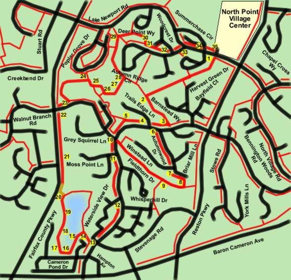
Directions:
This walk provides a loop trail to Cameron Pond prior to the completion of a small section of asphalt trail along the Fairfax County Parkway. For that reason a short portion of the walk utilizes gravel paths that will serve as ballast for the asphalt trail. The walker may encounter trail construction at some point in the future. Should that be a problem the walker can complete the loop trail around the pond and return to the starting point by retracing their steps from point 14 to point 1 on the map. The gravel paths are in good condition and can be viewed by clicking on point 20 on the map.
Two alternate routes are provided. The extended route has been added to meet the 3-mile requirement for the Reston Walkers. The short route provides a more direct route only 0.2 miles shorter.
- The walk starts adjacent to the Lake Newport Road entrance to the North Point Village Center. Take the wide asphalt trail directly across Lake Newport Road from the entrance road. A soccer field will quickly appear on the left. The trail will enter the woods. Do not take the narrow asphalt paths to the left or right.
- At the end of the trail take the wide asphalt trail to the left. A bench will appear on the left. The trail will continue through the woods up a hill.
- The trail intersects with Bennington Woods Road. Turn right onto the wide asphalt trail along that road. To use the short route stay on the path along Bennington Woods Road and go to point 4 in these instructions. To use the extended route turn left and cross Bennington Woods Road after reaching Autumnwood Drive. Go to point 6 in these instructions.
- (Short route) Continue on the trail along Bennington Woods Road as it crosses Trails Edge Lane. The trail enters the woods.
- At the next trail intersection turn left to continue along Bennington Woods Road. Go to point 10 in the instructions where both routes rejoin.
- (Extended route) After crossing Bennington Woods Road take the sidewalk along Autumnwood Drive.
- The trail crosses Winstead Lane. Continue on the sidewalk along Autumnwood Drive.
- At the end of Autumnwood Drive turn right and follow the wide asphalt trail between the houses. After passing between the houses turn right onto the wide asphalt trail in back of the houses.
- At the next wide trail intersection continue straight along the current trail. The trail will eventually intersect with Bennington Woods Road. Cross Bennington Woods Road at the crosswalk and turn left to follow the wide asphalt trail south along that road.
- The short and extended routes join together at this point. Continue south on the wide asphalt trail along Bennington Woods Road from Walnut Branch Road.
- The trail crosses Moss Point Lane. Continue along Bennington Woods Road.
- The trail crosses the first appearance of Waterside View Drive. Continue along Bennington Woods Road.
- The trail intersects with the second appearance of Waterside View Drive. After crossing that road turn right and follow the wide asphalt trail on the other side.
- After a short distance turn left onto the wide asphalt trail. Cameron Pond should be on your right after making that turn.
- The trail follows Cameron Pond with buildings on the left.
- The trail intersects with Cameron Pond Drive. Turn right and follow the sidewalk along that road.
- Before reaching the next building turn right onto the wide asphalt trail.
- The trail goes between the pond and the buildings.
- The buildings disappear on the left.
- Turn left onto the gravel path leading to the Fairfax County Parkway just north of the sound barrier. At the parkway turn right and follow the gravel path along the edge of that road. If construction is a problem continue on the trail around the pond and return to the starting point upon reaching point 14 on the map.
- The completed asphalt trail begins within a short distance. Geese are shown feeding in the median of the parkway. They are constantly walking in front of cars to do so.
- The trail intersects with Walnut Branch Road on the east side of the parkway. After crossing Walnut Branch Road turn right and take the wide asphalt trail going east alongside.
- Turn left onto the first wide asphalt trail. The trail starts to head back towards the parkway and then makes a U turn heading back in an easterly direction.
- At the first wide trail intersection turn right next to the athletic field. The trail will quickly turn left again.
- At the next trail intersection go straight. The trail will pass tennis courts.
- Turn left onto the wide asphalt trail at the swimming pool.
- The trail joins a pipeline and goes up a hill through the meadow.
- Turn left onto the wide asphalt trail at the top of the hill.
- At the next wide asphalt trail turn right. Do not take the narrow asphalt trail on a sharp right that leads to a flight of steps.
- The deer shown on the path were adjacent to Deer Point Way. The path re-enters a pipeline area.
- After leaving the pipeline the trail continues east along Autumn Ridge Circle.
- The trail crosses Woodcrest Drive continuing east along Autumn Ridge Circle.
- The trail intersects with Lake Newport Road. Cross that road and turn right along the wide asphalt trail on the other side going east.
- The trail crosses Summerchase Circle. Continue east along Lake Newport Road.
- The trail reaches the starting point at the North Point Village Center.