Sugarland Run - Herndon Section
Sugarland Run - Herndon Section
Length: 1.0 miles
Surface: paved trail and sidewalks
Exposure: shade and sun
Surroundings: woods, buildings, streets
Directions:
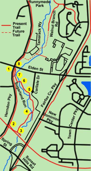
Herndon is building a new trail (June 2005) to connect from an existing Fairfax County trail on the eastern side of Sugarland Run to the W&OD Trail. (The existing Fairfax County trail is shown on the Sugarland Run Stream Valley Map on this site.) The section of new trail between the W&OD Trail and Elden Street has been paved and is suitable for use. The section north of Elden Street is still under construction. This guide gives directions for a loop walk on the paved section of trail.
- The walk starts at the intersection of Elden Street and Herndon Parkway. You might park in one of the shopping center parking lots near that intersection. Walk in a southerly direction on the sidewalk along Herndon Parkway with woods on your left.
- The W&OD Trail crosses Herndon Parkway on a bridge. Just prior to the bridge turn left to follow a crushed stone trail up the hill.
- At the top of the hill at the junction with the W&OD Trail turn left to follow a paved intersecting trail back down the hill. A paved trail intersects from the left at the bottom of the hill. Turn left to follow that trail.
- The trail turns right to cross a bridge over Sugarland Run. An old trail intersects from the right. Stay on the new trail as it turns left to follow Sugarland Run.
- The picture shows construction equipment putting finishing touches on the land around the trail.
- The trail crosses Sugarland Run again and follows it on the other side.
- This was a construction entrance for the trail. The trail crosses a stream at this point.
- The trail intersects with Elden Street back at the start of the walk.