Sugarland Run - Sugarland Road 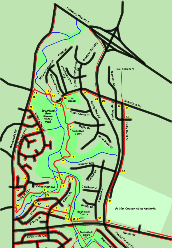
Sugarland Road
Length (east loop): 2.9 miles
Length (west loop): 3.0 miles
Surface (east loop): paved trail with some road shoulders
Surface (west loop): paved trail and sidewalks
Exposure: shade and sun
Directions:
This walk covers the trail system in Sugarland Run Stream Valley Park between Wiehle Avenue and Sugarland Road. It includes 2 return loops, one to the west along Dranesville Road and the other to the east along the Fairfax County Parkway. The east loop uses the shoulder of Sugarland Road in 1 place for a short distance. The walk starts outside of Reston in order to keep walking distances in the 3 mile range. Walking this route from Stuart Road Park in Reston would add 2.5 miles to the hike should you care to try it.
The walk involves several stream crossings on columns and high waters can be a concern. You may wish to take the Sugarland Run Introduction walk to get acquainted with column stream crossings before attempting this walk.
- The walk starts from Cassia Street at the pipeline right of way between Cliveden Street and Exbury Street. Take the asphalt trail to the east. The trail will go down the hill towards Sugarland Run. (Cliveden Street can be found off of Dranesville Road about .7 miles north of Herndon Parkway.)
- The trail intersects with another asphalt trail. Turn left. The trail will enter the woods and a play area will be seen on the right followed by a basketball court on the left. The trail follows Sugarland Run which will be on the right.
- An asphalt trail intersects from the left. Continue straight on the present trail which will soon turn to the left.
- The trail enters a clearing and intersects with an asphalt trail. Take the trail to the right. It will shortly turn to the left to enter the woods.
- An asphalt trail intersects from the left. Continue straight on the present trail.
- The trail crosses Sugarland Run on columns. The slope of the ramp at this crossing is steep. Note the tree in the stream on the left that the beavers have been unable to fell.
- The trail curves around houses on the right and crosses another stream on columns.
- The trail curves sharply to the left. There is a natural surface path at this location but it has become overgrown. It is not shown on the map for this reason.
- The trail enters a basketball court. At the rear of the basketball court at the stream a homemade crossing has been built. This crossing is also not shown on the map for obvious reasons. An asphalt trail intersects from the right just after the basketball court. Continue on the present trail to the left following the stream.
- An asphalt trail intersects from the right. Turn right and follow the trail up the hill to return on the east loop. Go to point 26 in the instructions. Turn left and follow the trail along the stream to return on the west loop. Go to point 11 in the instructions.
- (West loop) The trail continues through the woods with the stream on the left. On the right it will pass the abandoned paved portion of Sugarland Road.
- An asphalt trail intersects from the right. Turn left.
- The trail shortly crosses Sugarland Run on columns. The picture shows some of the life in the water at the edge of the concrete crossing ramp.
- The trail comes to a gravel road in a clearing. Turn left and follow the gravel road up to the highway.
- The gravel road intersects with Dranesville Road. Turn left and follow the asphalt trail along Dranesville Road.
- At the next intersection turn left and follow the sidewalk along Butter Churn Road.
- Turn right at Shallow Ford Road and follow the sidewalk along that road.
- Continue along Shallow Ford Road until it ends. The picture shows the road as it passes Valley High Road.
- Turn left at the end of Shallow Ford Road and follow the asphalt trail along Dranesville Road.
- Turn left at the next asphalt trail (a distance of about 1 block). It will enter the meadow and make numerous turns eventually following a stream to the east.
- The trail crosses the stream on columns. After crossing the stream turn right at the trail intersection. The trail goes up the hill between the houses.
- The trail ends at Cliveden Street. Cross the road and take the sidewalk to the right.
- Upon reaching the pipeline right of way turn left and follow the asphalt trail for one block.
- The trail intersects with Cassia Street where the walk started. (End west loop)
- (East loop) The trail climbs the hill and meets the travel portion of Sugarland Road. It ends in the shoulder of that road. Continue along the shoulder to Bandy Run Road.
- The asphalt trail reappears on the other side of Bandy Run Road. Continue on the trail along Sugarland Road to the Fairfax County Parkway.
- Cross the Fairfax County Parkway to the asphalt trail along Sugarland Road on the far side.
- Continue on the asphalt trail along Sugarland Road to Sugar Maple Lane.
- After crossing Sugar Maple Lane continue on the asphalt trail to Holy Knoll Drive.
- Turn right onto the asphalt trail on the far side of Holly Knoll Drive. Note the sign marking the entrance to the Fairfax County Water Authority.
- The asphalt trail crosses the second appearance of Sugar Maple Lane. Continue on the trail.
- The asphalt trail crosses to the other side of Holly Knoll Drive near the gated entrance to the Water Authority.
- The Fairfax County Parkway joins the trail at this point. Continue on the trail along the parkway.
- The trail intersects with Wiehle Avenue. Turn right and cross the Fairfax County Parkway. Walk along the right side of Wiehle Avenue.
- A trail intersects from the right leading to Rowland Drive. Continue straight on the trail along Wiehle Avenue.
- A trail intersects on the left from under Wiehle Avenue. Continue straight on the present trail to the stream.
- The trail crosses Sugarland Run on columns.
- After crossing the stream the trail climbs a small hill. Turn right to follow the trail away Wiehle Avenue.
- An asphalt trail intersects along the pipeline right of way. Turn left and follow the trail up the hill.
- The trail intersects with Cassia Street where the walk originated. (End east loop)