Peterson Lane Park
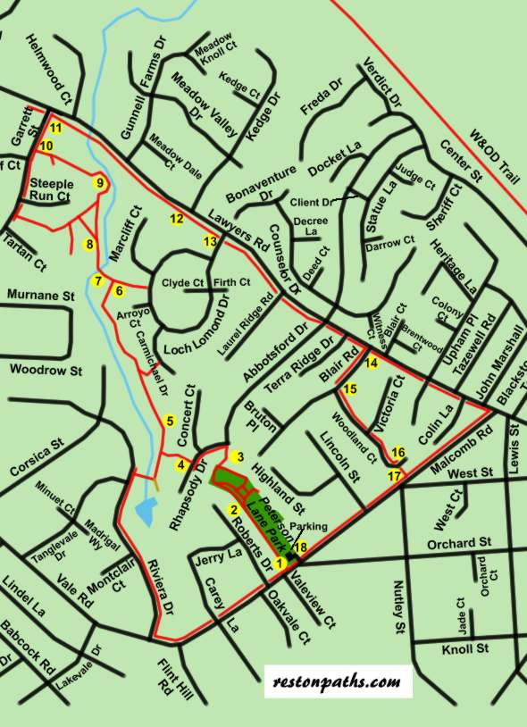
Peterson Lane Park
Length: 2.6 miles
Surface: paved
Exposure: sun and shade
Surroundings: woods, park, roads
Directions:
The paths in Reston were planned by a single land development company and cover a large area. Since Reston was started other developers have created pathway systems on a smaller scale. Just west of Vienna between Lawyers Road and Vale Road the developers coordinated their efforts and created a pathway following a creek that runs through 3 developments. The paths are owned and maintained by the community civic associations. This walk will take you through that area to show how developers working together can create a pathway system that ties what might be 3 separate neighborhoods together.
- The walk starts from the parking lot of Peterson Lane Park. The parking lot cannot handle a large number of vehicles. Walk over to the service road on the south side of the park and follow it west away from Malcomb Road. The service road used to be known as Peterson Lane.
- An asphalt trail branches out to the right with one part leading to playground equipment. Continue straight on the service road which changes to a gravel surface.
- At the end of the service road turn right onto the asphalt trail that joins it. The trail leads between 2 wooden fences and cuts between houses. The trail intersects with the end of Abbotsford Drive. Turn left and walk a very short distance to intersect with Rhapsody Drive. Turn left to follow the sidewalk along Rhapsody Drive.
- Shortly after passing Concert Court on the right turn right to follow an asphalt path between the homes on Rhapsody Drive. This trail ends at another asphalt trail that runs besides a creek. Turn right onto that asphalt trail and follow it along the creek.
- A marker indicates that you are entering another civic association pathway segment. Continue straight and do not turn at the next asphalt trail leading up the hill to the right.
- A trail intersects from the right and a basketball court can be seen on the left. Continue along the present trail as it turns to the left.
- The trail crosses the creek. This marks the boundary line with another civic association. Continue straight on the paved path.
- An asphalt path intersects from the left. It may be somewhat difficult to see. Continue straight on the present path continuing to follow the creek. Continue past the next asphalt trail to the left also.
- The trail turns left to follow the creek. It then jogs to the left to pass on higher ground through a short section of trees. The creek leaves the trail just past this point.
- Turn right and follow the concrete sidewalk along Garrett Street.
- Turn right and follow the asphalt trail along Lawyers Road.
- After crossing the creek the trail goes uphill along Lawyers Road.
- The trail crosses Loch Lomond Drive. Continue straight as the trail follows Lawyers Road across 3 more intersecting roads.
- As the trail enters Vienna turn right onto the concrete sidewalk along Blair Road.
- Turn left after walking one block and follow the concrete sidewalk along Woodland Court walking past Victoria Court.
- Woodland Court turns to the left. Take the walkway between the houses at this point so that you continue to walk in the same direction as Woodland Court before it turned. The walkway passes down some steps to intersect with Malcomb Road.
- Turn right and follow the concrete sidewalk along Malcomb Road for 2 blocks.
- The parking lot at Peterson Lane Park signals the end of the walk.