 You
may have seen a map like this on a post besides a Reston trail. This map is
used to guide people along designated routes. Existing marked routes include
Northpoint, Lake Anne, Tall Oaks, South Lakes, Hunters Woods, and Town Center.
More routes are in the works.
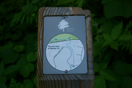
You
may have seen a map like this on a post besides a Reston trail. This map is
used to guide people along designated routes. Existing marked routes include
Northpoint, Lake Anne, Tall Oaks, South Lakes, Hunters Woods, and Town Center.
More routes are in the works.
 The maps
and signs are the creation of Jerry Waters. Jerry used to create maps for
the Geological Survey for money and now does it for Reston for free. Every
post (of which there are many) has an individual map illustrating the nearby
area in detail. He also created paper maps of the entire routes available
on the Reston
Association web site or at their office. Try the routes, you will be healthier
for doing so.
The maps
and signs are the creation of Jerry Waters. Jerry used to create maps for
the Geological Survey for money and now does it for Reston for free. Every
post (of which there are many) has an individual map illustrating the nearby
area in detail. He also created paper maps of the entire routes available
on the Reston
Association web site or at their office. Try the routes, you will be healthier
for doing so.
Although I don't have a picture his wife Marie Vincent also deserves mention here. She led the Reston Association Facilities Advisory Committee for many years keeping us members focused on the task of creating these routes. She and Jerry will be moving to the west coast soon and we will miss their efforts on behalf of the people of Reston.
Thank you Marie and Jerry for making Reston a better place.