Parkway to Pipelines
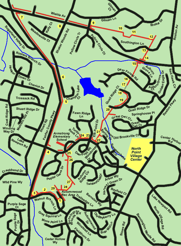
Parkway to Pipelines
Length: 4.1 miles
Surface: paved trail, sidewalks, short grassy section
Exposure: sun
Surroundings: roads, pipelines, homes
Directions:
This walk will take you on a new section of the Fairfax County Parkway that opened around the start of 2001. From there you will follow a portion of Wiehle Avenue that was opened within the previous year. You will return following portions of 2 pipelines that cross Reston.
There is still construction on portions of the trail along the Fairfax County Parkway so walkers should be on the lookout for obstacles that might cause falls.
- The walk starts at the parking lot for the Autumnwood Recreation Area. It is located off Walnut Branch Lane near the intersection with Bennington Woods Rd. Take the short asphalt trail directly across the parking lot from the pool building. Turn right at the wide asphalt trail along Walnut Branch Lane.
- A wide asphalt trail branches off to the right. Remain on the trail along Walnut Branch Lane.
- At the intersection with the Fairfax County Parkway turn right to follow the trail along the Parkway.
- The trail and Parkway intersect with Lake Newport Road next to Armstrong Elementary School. Remain on the trail along the Parkway. Shortly after passing the school you will be leaving Reston.
- The trail curves to the left and starts down hill near Cheviot Drive. The Parkway split Cheviot Drive and Stuart Road and one must now drive over a mile to go from one portion of the roads to the other. The northern portion of Stuart Road has been renamed Shaker Woods Rd. The eastern portion of Cheviot Drive has been renamed Champion Lake Ct. The buildings belong to the Fairfax County Water Authority. Sugarload Mountain can be seen in the distance on a clear day. It is 19 miles away as the crow flies but takes over an hour to reach by auto from this location.
- The road to the right of the trail was built to connect the eastern portion of Cheviot Drive (Champion Lake Ct) to the northern portion of Stuart Road (Shaker Woods Road). The lovely older home previously on the west side of the Parkway and shown in the picture was just barely out of the demolition path for the Parkway. However, it has now been demolished to build new homes on the property.
- The Parkway intersects with Wiehle Avenue. Cross Wiehle Avenue, turn right and follow the asphalt trail eastbound along Wiehle Avenue.
- Wiehle Avenue intersects with Shaker Woods Road. Cross Shaker Woods Road at this point and continue following Wiehle Avenue on the northern side. There are fences on both sides of Wiehle Avenue in this block.
- Wiehle Avenue intersects with Pellow Circle Trail. Cross that road and turn left on the wide asphalt trail. Within a few feet turn right to follow the asphalt trail along the pipeline right of way.
- There is a fence across the pipeline right of way at the top of the hill. The trail turns right and enters the woods. It then parallels the pipeline.
- The trail leaves the woods and re-enters the cleared portion of the pipeline. Continue on the trail.
- The trail intersects with another pipeline and trail running in a perpendicular direction. Turn right and follow the trail along the new pipeline.
- The trail crosses Southington Lane and goes down a hill.
- The trail reaches Wiehle Avenue. Cross at the crosswalk and continue past the sidewalk on the other side to cross the stream. You are now back in Reston. Turn right to follow the asphalt path a short distance.
- The trail turns left and goes up a short hill through a wooded area. At the top it crosses a private driveway and re-enters the pipeline area. Continue to follow the trail along the pipeline.
- The trail crosses Deer Forest Road. Continue along the pipeline.
- At the top of the hill the paved trail ends. Continue walking across the grass to the next road.
- Cross Quail Ridge Court and turn left to follow the sidewalk on the far side. Photo 18a shows the pipeline on the other side of the hedge but the walk takes a slight detour at this point to follow the street.
- Continue along the sidewalk past the intersection with Quail Ridge Drive.
- Near the other end of Quail Ridge Court turn left to follow the trail along the next section of pipeline. After passing the house another trail joins from the left. Continue on the trail along the pipeline and go up the hill.
- Near the top of the hill another narrow trail goes off to the left. Continue along the main trail along the pipeline.
- The trail reaches Lake Newport Road. Turn right to follow the wide asphalt trail along that road.
- The trail crosses Elk Point Drive. Continue to follow the present trail.
- A wide trail intersects from the right. Continue to follow the present trail and Lake Newport Road.
- Cross Lake Newport Road at the crosswalk just prior to Armstrong Elementary School. On the other side take the wide trail to the left down the short hill. Do not take the trail to the right down the steps.
- Continue on the present trail past the wide trail intersecting from the left. Also, do not turn right onto the narrow trail intersecting shortly afterwards from the right.
- The trail re-enters the pipeline right of way. Turn right to follow the intersecting trail along the pipeline.
- The trail turns right and a pool appears on the left. Follow the trail along the pool and do not take the next trail to the right.
- The trail turns left at the end of the pool fence. The trail leads from this point back to the parking area where you started.