Old Courthouse Road Conditions
Changes will be made to Old Courthouse Road to improve safety in the vicinity of Besley Road and to provide a trail along that road to improve pedestrian access. This document has been created to illustrate some of the conditions on that road. First, a look at the area as it appeared over 100 years ago versus the present.
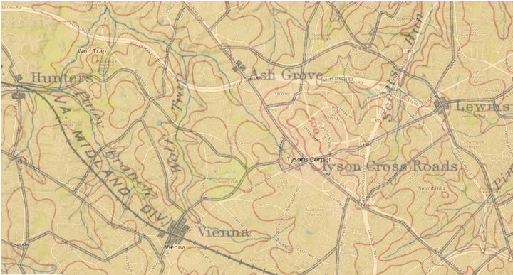
The present road structure is shown in white against the older map. Realize that the older map was based on surveyors drawings while the current map utilizes aerial photographs. Note that the road between Creek Crossing Road and Beulah Road has not changed much in 100 years. Both maps were created by the U.S. Geological Survey. Click on the map for a larger image.
I decided to add Foxstone Park to my growing inventory of walkable trails in Fairfax County to this website. I started in Vienna at E St. NE and Church St. NE. At the other end of the trail system I ended up at Old Courthouse Road. There was no connection to anywhere and the local residents had no safe means to access the park from this point. Later I followed Old Courthouse Road and found Wolf Trails Park a short distance away. There was a roundabout trail from this park via a connection at Arabian Ave. but it ended up on the other side of Wolftrap Creek. Old Courthouse Road is too narrow for pedestrian use so a connection between these trails would be dangerous. The solution to me was to build a trail across Wolftrap Creek adjacent to Old Courthouse Road.
Wolftrap Creek can best be described as naughty. It refuses to stay within it's banks and has washed out a few pedestrian bridges and one section of a Foxstone Park trail. The grounds near the creek can get pretty wet during the rainy season. I was told that such a connection across the creek would be impossible.
Washington has been determined to be the number one fitness area in the country. People here like to walk and the Old Courthouse Road neighbors are no exception. The Fairfax County Park Authority has a goal of connecting all of it's many parks by trails. That is partly the reason that we are meeting. The other part is that the neighbors are afraid to walk across the street becaue of poor visibility and speeding vehicles. So the other reason we are meeting is to improve pedestrian and vehicle safety along this road.
There is a feeling that the turn to cross Wolftrap Creek makes drivers slow down and increases the safety of the road. The road used to jog around an oak tree near the intersection with Creek Crossing Road. A teenager lost his life hitting this tree on July 25, 1987. There was a debate about removing the tree. The tree did not die from natural causes. Placing hazards in roadways does not make them safer, especially where younger drivers are involved.
The next section describes the conditions east of Besley Road.
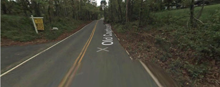
There are 3 locations east of Besley Road that pose some hazard to the residents there. Site 1 has 2 driveways east of Besley Road. Visibility is poor looking west towards the curved road across the creek. A 3 way stop sign at Besley Road would slow eastbound drivers reducing the hazard here. The following images show the sight lines west and east.:
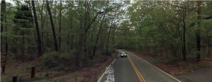
site 1 looking west
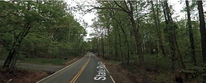
site 1 looking east
Don't worry about the center lines. These are separate images pasted together. The view to the east appears adequate and a stop sign at Besley or the straightening of the road across the creek would be useful.
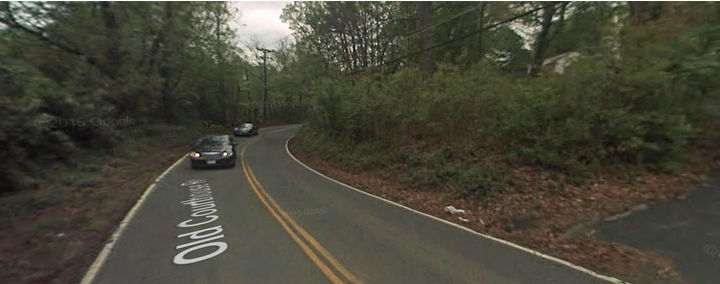
The next images show the view from site 2 both west and east.
site 2 looking west
site 2 looking east
Site 2 has fair visibilty from the west but poor from the east because of the curve in the road. Now on to site 3.
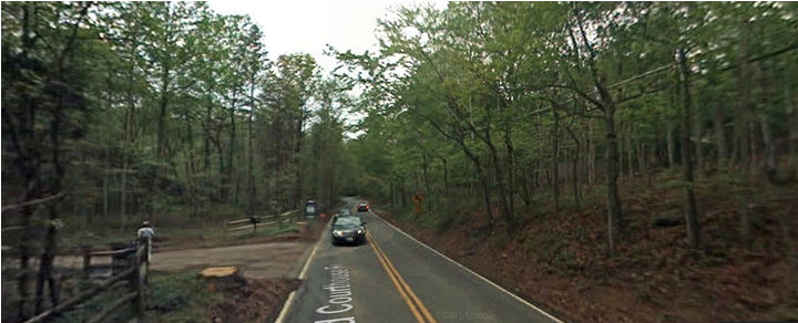
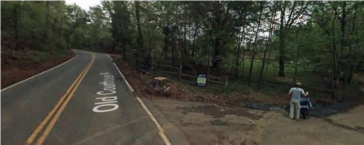
site 3 looking west
site 3 looking east
Site 3 cannot see traffic coming from the west. The vision from the east is good. Special attention is needed here.
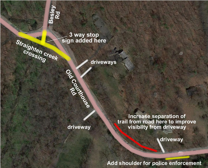
Here are proposed changes to this section of road to improve safety:
1. Straighten
the road where it crosses Wolf Trap Creek. This will improve visibility and
improve safety under wet road conditions.
2. Place a 3 way stop sign at the intersection with Besley Road. This will
gain the attention of distracted drivers. This is similar to the situation
on Lawyers Road where it enters the town of Vienna. There is a 4 way stop
sign at Upham Place. There are seldom any vehicles entering Lawyers Road from
Upham Place.
3. Increase the separation of the trail from the road at the next curve in
the road. The trail should be at the same height as the road with the brush
cut between road and trail. This will increase visibility around the curve.
Note that the driver turning left from the driveway does not currently have
the visibility to enter the road safely. Eastbound drivers turning left into
the driveway and halting for traffic moving westbound are liable to be rear
ended here.
4. Build a shoulder on the southern section of the road here for law enforcement.
Local drivers cannot see a police car parked here and will slow down on the
chance that a police car is present. Drivers not familiar with the curve will
slow down since they are unfamiliar with the curve. Eastbound drivers on a
down hill stretch of Sunrise Valley Drive in Reston slow down prior to Indian
Ridge Road because the police often park behind the bushes there for traffic
enforcement.
Proposed road improvements
Some of the above changes are somewhat controversial and may involve the granting of easements by property owners. They may also exceed the amount budgeted for this work. Any of the changes may be discarded without impacting the other proposals.
Here is a final view of this proposal:
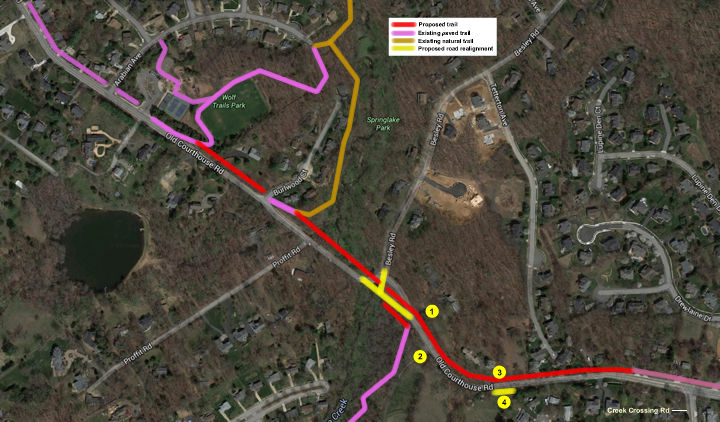
A trail is placed on the northern side of Old Courthouse Road to join existing trails on that side. If a stop sign in placed at Besley Road than a trail is placed on that side from Besley Road to the entrance to Foxstone Park. This is done whether the road over Wolftrap Creek is straightened or not.The trail west of site 3 is built some distance to the road to provide better sight distance around the curve. A shoulder is placed on the southern side of the road to provide parking for police cars.
Click on the picture for an enlarged view of the image.
The trail to Foxstone Park provides walking access to the Cardinal Hill Swim and Racket Club, Wolf Trap Elementary School, Creek Crossing Road, and downtown Vienna. I named the park Spy Park on my website to encourage more people to walk the park. It is the site of a transfer of secret documents by an FBI agent to the Soviets.
This proposal contains images from Google Maps and the Geological Survey.