Lake Thoreau
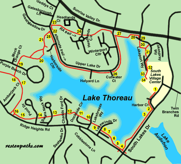
Lake Thoreau
Length: RA route 2.1 miles
Length: alternate route 2.3 miles
Surface: paved trail and sidewalks
Exposure: sun and shade
Surroundings: lake, homes, meadow, golf course
Directions:
This walk starts from the parking lot at the South Lakes Village Center on South Lakes Drive at Twin Branches Road.
- Start at the sidewalk on the side of Starbucks and walk towards the back of that building in the direction of South Lakes Drive.
- At South Lakes Drive turn right and follow the asphalt path with the road on your left.
- The trail crosses the dam for Lake Thoreau.
- The trail intersects with another trail that comes under South Lakes Drive. Turn right away from the tunnel. Within a few feet there is an intersection with another trail coming under Ridge Heights Road. Stay straight on the current path that follows the lake and do not enter the tunnel to the left.
- The trail climbs a short hill to a town house area.
- Stay to the right along the town houses.
- The trail goes behind the houses and offers another view of the lake.
- The trail intersects with Lakewinds Drive. The trail resumes on the other side of the road a short distance to the right. Use the asphalt trail.
- Note the artificial pond to the left of the trail.
- The trail crosses Lakebreeze Way. Notice the sign from the National Wildlife Federation marking this area as a backyard wildlife habitat.
- Pass a parking area at the end of Dockside Circle with homes to the right. Stay on the wide asphalt path that winds up the short hill just past the homes.
- The trail crosses Chadds Ford Drive between the homes.
- The trail crosses Swans Neck Way.
- The trail crosses Pond Drive and curves slightly to the left to follow Ridge Heights Road.
- The trail crosses a driveway to the parking area for Ridge Heights Pool.
- The next trail to the left leads to a sidewalk along Ridge Heights Road. Stay on the current trail that intersects with a trail under Ridge Heights Road. Turn right onto that trail and walk down hill between the homes.
- The trail crosses a wooden bridge and enters a meadow. It turns left up the hill.
- Playground equipment appears on the left. Turn right onto the asphalt trail just past this equipment.
- The trail crosses Purple Beech Drive and enters the woods. It turns right just prior to the golf course and goes down a steep hill.
- The trail crosses a wooden bridge over an inlet to Lake Thoreau. It then turns left up the hill.
- The trail enters the golf course area for a short distance.
- The trail intersects with Upper Lake Drive. At this point you may choose to follow the Reston Association trail (the short route) or an alternate longer route along Upper Lake Drive. If this is your first time on the path try the short route and come back again to do the longer route. You will enjoy both. Go to point 25 to follow the alternate route. To follow the Reston Association trail cross Upper Lake Drive and take the sidewalk to the left just past the intersecting road on the left.
- Turn right onto the asphalt trail through the trees. The trail wanders between homes and goes up a short hill.
- The trail crosses Headlands Circle next to the circle. It turns to the left along a field and follows Sunrise Valley Drive for a short distance. It intersects with Upper Lake Drive across from the Lake Thoreau Pool. Go to point 27 in the directions. (Points 25 and 26 are for the alternate route.)
- Turn right onto Upper Lake Drive and follow the sidewalk The route will cross Harborside Cluster and Halyard Lane.
- This view at Cutwater Court will confirm you are still on the alternate route. Continue to follow the sidewalk for another block.
- Both routes rejoin at this point at the Lake Thoreau Pool. Follow the asphalt path between the pool and the parking lot toward the lake.
- The trail turns left and goes up a short hill to Sunrise Valley Drive. Many of the high tech companies are located in the buildings across the street. Turn right onto the first street, which is Lakeport Way.
- The trail crosses the street and goes between the houses. The trail is next to the railing in the picture.
- The trail goes down to the lake and turns left for a short distance, then turns right again to cut between the houses.
- The trail crosses Lakeport Way again at the fire hydrant in the picture. Turn right and follow the trail along a wall.
- The trail goes down a small hill behind stores in the shopping center.
- This is the view from the dock at the South Lakes Village Center.
- Walk up the steps to enter the shopping area and return to your starting point.
An aerial photo of the Lake Thoreau area is available. It will take some time to download. To view the photo click here.