Glade Stream East
Click here for map in pdf format for printing.
Click here for start of walk in Google Maps.
Glade Stream East
Length (short loop): 2.5 miles
Length (medium loop): 2.9 miles
Length (long loop): 3.1 miles
Surface: paved trail and natural surface trails
Exposure: sun and shade
Surroundings: woods, wetlands, wildflower garden, streets
Directions:
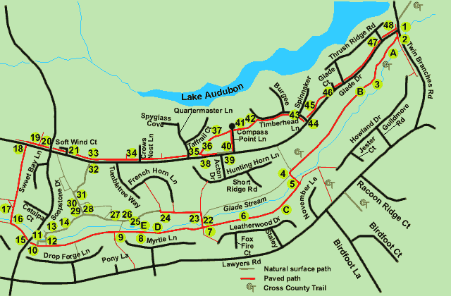
The Glade East trail has been separated into 3 loops, short, medium, and long. The short loop consists of both paved and natural paths. It passes by the Glade wetlands pool, a source of some controversy for several years. The medium loop also consists of both paved and natural paths. It passes through the Nature Center Wildflower Trail. The long loop is paved for the whole length and passes the Glade Drive Swimming Pool. All 3 loops pass the site of the proposed expanded Walker Nature Education Center Nature House.
- The trail begins at the southwest corner of Glade Drive and Twin Branches Road. Take the path down the hill with a display map of the area on the right.
- After walking about 150 feet turn right onto the intersecting trail. Metal vehicle barriers mark the trail. The trail parallels the stream.
- After crossing several hills the trail levels off. Beavers have taken many of the trees near the stream on the left.
- The trail turns left and crosses Glade Stream.
- Turn right at the next trail intersection and follow the paved trail through a short wooded section.
- The back yards of homes can be seen on the left. The area on the right is mostly wetlands created by beavers.
- At the next trail intersection the medium and long loops go straight. To follow the short loop turn right and go to point 22 in these directions.
- (Medium and long loops). The trail continues to parallel the stream. The picture shows a section of trail under repair after the stream eroded the earth underneath it.
- A paved trail from Lawyers Road intersects on the left. Continue straight on the present trail.
- About 40 feet prior to the intersection with Soapstone Drive a sign on the right marks the Nature Center Wildflower Trail. Turn right onto either natural trail to follow the medium loop. To follow the long loop continue straight on the paved trail and cross Soapstone Drive. The instructions for the long loop continue at point 15.
- (Medium loop) Both natural trails rejoin and split again. Continue on either path until they rejoin for a second time at a display case. While facing the display case take the natural path to the left along the stream (as shown by the arrow in photo 11). The correct path will be following the stream in the direction of flow.
- The trail intersects with another natural path. Turn left and cross the stream on the bridge shown.
- The trail intersects with another natural path. Turn right and follow the new path.
- The soldiers shown on the path are from Germany and are taking a required annual 30-kilometer hike. The path crosses a small hill. After crossing the hill turn left at the next trail intersection. Go to point 29 in the instructions where the short loop and medium loop rejoin.
- (Long loop) After crossing Soapstone Drive continue to follow the paved path on the other side.
- At the first intersection turn right to follow the paved path across the stream.
- At the next trail intersection from the left keep to the right to continue on the present trail up the hill.
- The path crosses Glade Drive at the tennis courts. Turn right and follow the path on the other side.
- The path crosses the entrance to the parking area for the Glade Swimming Pool.
- The path crosses Soapstone Drive. Continue on the paved path along Glade Drive.
- The path crosses Soft Wind Court. Continue along Glade Drive. Go to point 33 in the instructions where all 3 loops rejoin at the Walker Nature Education Center Nature House.
- (Short loop) The trail crosses Glade Stream.
- Turn left at the first paved trail. A play area will be on your left.
- A trail intersects from the right. Continue straight on the present trail until the trail suddenly turns right to go up the hill. Take the natural trail in the same direction that the paved trail was taking prior to the turn. (Don’t go up the hill.)
- The Glade wetlands pool is on the left. The appearance changes with the season.
- A natural trail intersects from the left. Continue straight on the present natural trail.
- Cross a bridge over small creek. Do not take the narrow natural trail to the right just past the bridge.
- The trail intersects with a wide natural trail to the right. Turn right. The medium loop rejoins the short loop at this point.
- (Short and medium loops) The wide natural trail climbs a hill.
- A trail with wooden steps intersects from the right. Continue on the present trail up the hill.
- A narrow trail intersects from the right. Turn right and follow the trail across the small gully.
- The trail intersects with Glade Drive. Cross Glade Drive and turn right onto the paved trail on the other side. All loops rejoin at this point.
- (All loops) The trail follows Glade Drive. Do not take any trails to the left until after crossing Quartermaster Lane.
- The trail crosses Crows Next Lane.
- After passing the first house after Quartermaster Lane the trail splits into a wide path down the hill to the left and a narrow portion along Glade Drive to the right. For those of you who like hills turn left to follow the paved hilly route. Otherwise, take the narrow path to the right to follow the flat route. There is a short section of natural path along the flat route. Go to point 38 in the instructions for the flat route. (My dog always pulled to the right at this point.)
- (Hilly route) The path goes down a steep hill between the houses.
- At the bottom of the hill the path turns and goes up a steep hill between the houses. At the top of the hill cross Compass Point Lane and go to point 41 in the instructions.
- (Flat route) Follow the narrow asphalt path along Glade Drive.
- At the next driveway the paved path ends. Follow the natural path along Glade Drive.
- Turn left onto the sidewalk along Compass Point Lane. At the intersection with the asphalt path from the left cross Compass Point Lane.
- The hilly and flat routes rejoin. Take the asphalt path between the houses just prior to the circle in the road.
- The paved path turns right and follows Timberhead Lane.
- Look between the houses to the right as you pass Spinnaker Court. The pond is in a development known as the Wharf.
- The trail intersects with Glade Drive. Cross Timberhead Lane and continue along the path along Glade Drive.
- The path leaves Glade Drive for a very short distance.
- The path crosses Glade Court. Continue along Glade Drive.
- The path crosses Thrush Ridge Road at 2 points. This is the second crossing.
- This is the intersection of Glade Drive and Twin Branches Road. You are now back at the starting point of the walk.
The following are descriptions of various sights spotted along the route and marked by circled letters on the map:
- Photo A1 shows an area near the start of the trail in March 2000. This was before the beavers arrived. Photo A2 (taken in April 2001 shows the area after beavers built a dam. Photo A3 shows water flowing over the dam. Photo A5 shows the water level in the pond getting close to the top of the sanitary sewer. This could divert the stream water into the sanitary sewer. Photo A6 was taken in May 2001 and shows the water level reduced considerably after action was taken to reduce the impact of the beaver dam.
- This box turtle is also taking advantage of the trail.
- This section of the trail is popular for strollers and we have seen single, double and triple varieties in use. Jogging strollers are also found along this section of trail.
- Mallard ducks can be seen in the stream in early spring.
- There are several hawks along the stream, one of which is pictured here. They are best spotted before the leaves emerge on the trees.