Foxstone Park (Spy Park)
Click here for a map in pdf format for printing.
Foxstone Park (Spy Park)
Length: 2.0 miles
Surface: paved or gravel
Exposure: shade and sun
Surroundings: woods, stream, homes, streets
Directions:
Foxstone Park is one of the places where newspapers report that FBI employee Robert Hanssen was passing secret information to foreign agents. Until his arrest I had never heard of Foxstone Park and curiosity drove me to look it over to see why this location was chosen. Having looked it over I still dont know why it was chosen except for the possible proximity to his home.
I named it Spy Park because the purpose of this site is to get people walking to keep them living longer. Curiosity is a powerful motivator and possibly you may also want to see the location where these escapades took place. I feel certain you will enjoy the walk through these grounds.
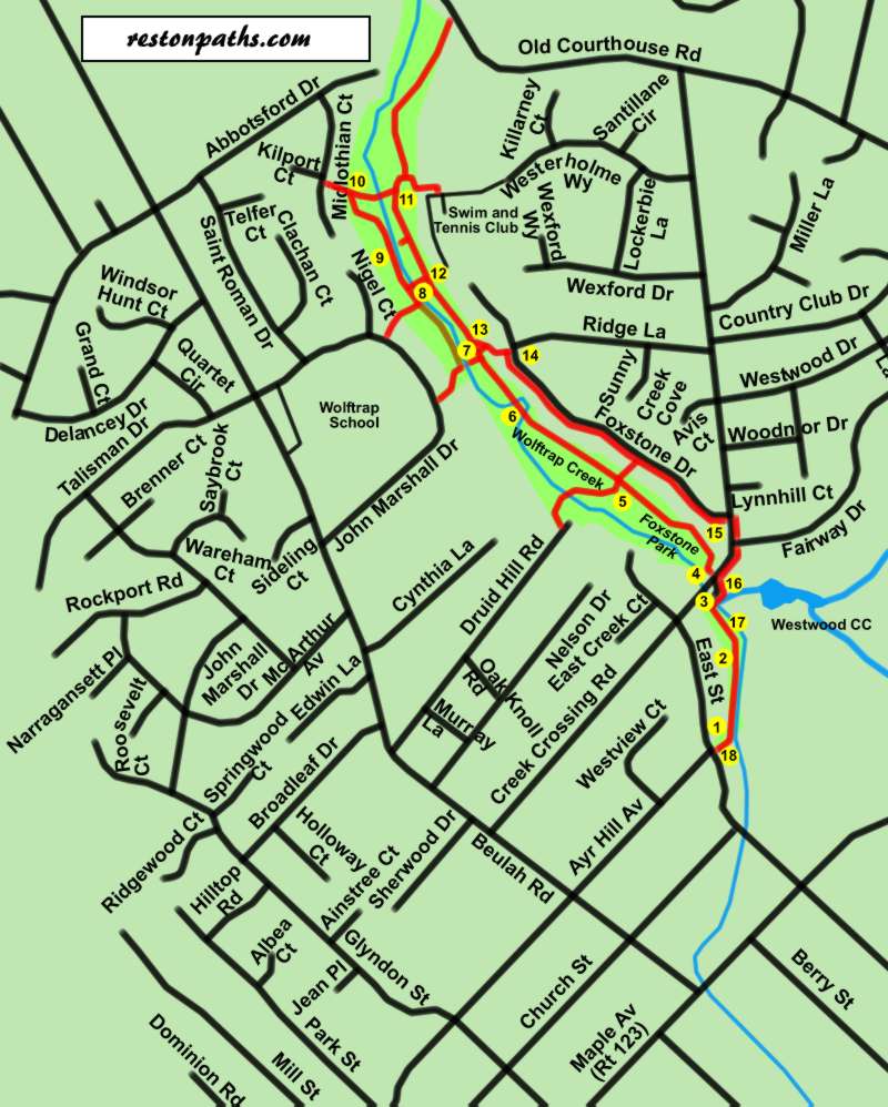
- The walk starts at the intersection of East Street and Ayr Hill Avenue in Vienna. Take the asphalt pathway on the north side of East Street adjacent to Ayr Hill Avenue. It leads into the woods.
- The trail turns left under the trees and Wolftrap Creek can be seen on the right and houses on the left.
- The trail turns right and crosses a bridge over Wolftrap Creek. It leads into a gravel access road. The Westwood Country Club can be seen through the fence on the right. Follow the gravel road to Creek Crossing Road.
- After crossing Creek Crossing Road at the crosswalk you will see an asphalt trail next to the Foxstone Park sign. Take the asphalt trail as it leads into the woods. Homes will be seen fairly close to the right of the trail. The creek will be on the left.
- A trail intersects on both sides just prior to a bridge. A high-tension electric line passes overhead and follows the creek. Stay on the trail that crosses the short bridge with the homes continuing on the right.
- The trail crosses over the creek twice within a very short distance. A June 2006 storm undermined part of the pavement here so be careful.
- The high-tension wires turn left and a trail intersects on the left. Continue straight on the current trail. (Note) The walk route used to turn left here but the asphalt trail on the other side of the creek has been removed and is only a dirt trail now. It can get very muddy in wet weather.)
- Turn left at the next asphalt trail intersection and cross the creek on a new bridge. This bridge was built in 2007. After crossing the creek turn right to follow the asphalt trail on the other side of the creek. Notice that the park is mowed in this area giving the homes on the left the appearance of being part of a large estate.
- A trail intersects on the right leading to a previous creek crossing. The June 2006 storms washed out this bridge. Continue straight on the present trail.
- The trail turns to the left away from the creek and leads to a trail that exits the park. Take a sharp right onto this trail heading back towards the creek. The trail crosses the creek on a bridge.
- Turn right at the next trail intersection. There will
be a basketball court on your left and the creek on your right.
(The trail to the left leads to Old Courthouse Road. That road is narrow at the intersection with the trail and there are no connecting trails or sidewalks at that location. You may wish to walk down to Old Courthouse Road and back as there is an interesting large estate on the right that has not been turned over to developers. This estate is less than a 5-minute drive to Tysons Corner.) - An asphalt trail intersects from the right. Continue straight on the present trail.
- A trail intersects from the left. Turn left and walk up the hill.
- The trail turns left and passes between houses to intersect with Foxstone Drive. Turn right to follow the sidewalk along this road.
- Foxstone Drive ends at Creek Crossing Road. Cross that road and turn right to follow the sidewalk on the other side. Cross Fairway Drive and continue along the sidewalk along Creek Crossing Road.
- After a short distance turn left and follow the gravel access road. At the end of the access road take the asphalt trail onto the bridge over Wolftrap Creek.
- The trail turns left under the trees and follows the creek on the left with homes on the right.
- The walk ends back at the starting point.
If you wish to learn where the secret papers were left before taking the walk click here to bypass the walk instructions.