Cross County Trail - Dulles Toll Rd. to Colvin Run
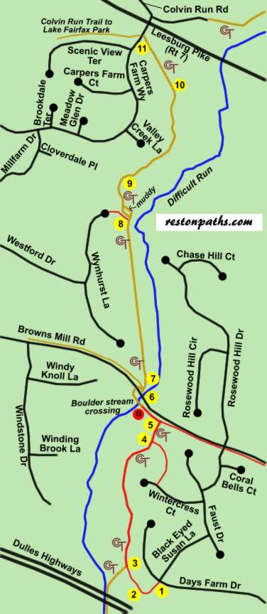
Cross County Trail - Dulles Toll Rd. to Colvin Run
Length: 3.4 miles round trip
Surface: asphalt, gravel, and natural surface
Exposure: sun and some shade
Surroundings: meadows, woods
Click here for a map and directions in pdf format for printing.
Click here to view the starting point on Google Maps
Directions:
This walk starts from a side trail beginning at Days Farm Drive adjacent to Black Eyed Susan Lane. This is the closest possible parking point next to the Dulles Toll Road where easy trail access is possible. On street parking is available.
- (North) Take the asphalt trail between the homes
adjacent to Black Eyed Susan Lane.
(South) The asphalt trail passes between the homes and ends at Days Farm Drive. This is the end of the walk in this direction. - (North) The trail turns to the right and passes
behind the homes on the right. A tennis court can be seen on the left.
(South) After passing a tennis court on the right the trail turns to the left to pass between the homes. - (North) The Cross County Trail intersects from
the left. Continue straight on the present asphalt trail as it becomes part
of the Cross County trail.
(South) If you wish to continue on to the next section of the Cross County Trail turn right at the intersecting trail to the right to pass under the Dulles Highways. To complete this section of the walk continue straight on the present asphalt trail. - (North) A side trail intersects from the right.
Continue straight on the present trail.
(South) A side trail intersects from the left. Continue straight on the present trail. - (North) The trail ends at an intersecting trail.
Turn left to follow that trail along Browns Mill Road.
(South) An asphalt trail intersects from the right. Turn right to follow that trail away from Browns Mill Road. - (North) The trail crosses Difficult Run on large
stones. After crossing the stream the trail turns right and crosses Browns
Mill Road through openings in the guardrails. Construction was still under
way when the pictures were taken and the crosswalk had not been painted
yet.
(South) After crossing Browns Mill Road the trail turns left and crosses Difficult Run on large stones. After the crossing an asphalt trail begins following Browns Mill Road. - (North) After a very short distance a gravel
trail intersects on the left. Continue straight on the present trail.
(South) The trail appears to ends at Browns Mill Road. Turn right and notice an opening in the guardrail. These pictures were taken before construction was completed and the trail will probably be realigned with the opening. Also, the crosswalk over Browns Mill Road had not been painted yet. Cross Browns Mill Road through both guardrail openings. - (North) After a considerable distance an asphalt
trail intersects from the left. Continue straight on the present trail.
After a very short distance it turns to the left and becomes a narrower
natural surface trail.
(South) After emerging from the woods the trail turns to the right and becomes a wider gravel trail. An asphalt trail intersects from the right. Continue straight on the present gravel trail. - (North) The trail passes through a section of
evergreen trees.
(South) The trail passes through a section of evergreen trees. - (North) The trail crosses a bridge over a muddy
section.
(South) The trail crosses a bridge over a muddy section. - (North) The trail crosses a grassy section and
ends at Carpers Farm Way across from the Colvin Run Trail. This is the end
of this section of the walk. You may return to the starting point using
the south directions. To continue on the CCT cross Route 7 at the traffic
light and follow the first road to the right off of Colvin Run Road.
(South) The trail starts in the grassy section adjacent to the vehicle barriers along Carpers Farm Way near Route 7.